
New Delhi, May17, 2020: The spread of coronavirus and lockdowns imposed across the country, has highlighted the need for geo-spatial technology to map Covid19 density zones to help enterprises to plan their business operations. Transerve Technologies through its offering 'Transerve Online Stack (TOS)' is tracking, monitoring, analyzing and visually representing geo-spatial data and helping organizations take statistically driven smart business decisions.
The need of the hour is to track the rate of spread of COVID-19 infections across geographies while alerting the uninfected about the proximity of such patients. Interactive Maps, which is a very important feature of TOS has become one of the most powerful tools to track, monitor and provide effective datasets on Novel coronavirus cases.
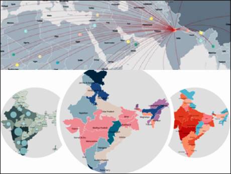
Large and medium sized retailers who are now hoping to re-open their stores are heavily dependent on geo-spatial datasets on deciding which outlets to open and which ones to not open. Similarly large manufacturing companies are using the geo-spatial data to analyze their suppliers’ catchment areas and effectively plan their sourcing strategies. Supply chain professionals across organizations and logistic companies are planning to extensively use geo spatial data for the route optimization of their vehicles by avoiding the red zones. Moreover, analyzing data of existing health infrastructure and census data sets and mapping it to those infected can help policymakers and concerned authorities in identifying COVID19 containment zones.
Such analysis can also estimate the load on each corona testing center and help health officials to set up more labs or increase or decrease the capacity of existing ones depending on population density and distance to the testing laboratory. TOS has been maintaining a Corona timeline and created interactive digital maps of all the districts in India, and colour coded them to map all the Covid19 related information.
Transerve platform allows users to perform analysis on the web on real-time through intuitive process and save the results for later use. The platform provides the functionality to collect data using mobile devices, manage, analyze, and publish the geospatial data on the web in real-time.
Amarsh Chaturvedi, Co-Founder, Transerve and IIT-Kanpur alumnus said, “Keeping a tap on COVID19 contaminated zone is the need of the hour. Our Government is playing best on their part to keep the citizens safe from infection. It is very important for new-age entities like ours to support the Government and corporations by making the utmost use of our technology in order to deal with this global crisis. Transerve’s technologically advanced API based spatial platform serves as a single point database to access all the information related to COVID19 contaminated zones.”