
July 17 2021: The Indian Ministry of Electronics & Information Technology (MeitY) has has enabled map services in the “UMANG App '' through an MOU with MapmyIndia.
As a result of this integration citizens will be able to find government facilities nearest to their location, such as mandis, blood banks and much more, at the click of a button. They will also be able to see these on the most detailed and interactive street and village level maps of India, built by MapmyIndia. Citizens will also be able to view the driving distance, get directions and turn by turn voice and visual guidance to locations, including traffic and road safety alerts during navigation, through the linkage between UMANG App and MapmyIndia.
The UMANG app has already started to provide map functionality through MapmyIndia in the following services:
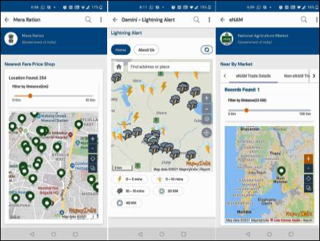
Mera Ration - Through UMANG, users can identify and navigate to the ‘Nearest Fair Price Shops’ as shops are visible in the form of pointers on MapmyIndia integrated map.
eNAM - Through UMANG, 'Mandi Near Me' service will help users to identify and navigate to the nearby mandis pointed on the map.
Damini - ‘Damini Lightning Alerts’ service is to provide lightning alerts to users by giving a visual ofnearby areaswhere lightning has struck in the last few minutes. This alert mechanism provides the possibility of lightning strikes on map view.
To further increase usefulness to citizens, the map functionality will be shortly enabled in many more services such as:
ESIC - Users can view ESIC centers such as hospitals/dispensaries on map view and navigate to them.
Indian Oil - Service is to locate nearby retail and distributors of Gas stations as well as fuel filling stations.
NHAI: Users can view the toll plazas and toll rates information while travelling.
National Crime Records Bureau (NCRB) provides information corresponding to nearby police stations on the map.
Pradhan Mantri Gram Sadak Yojana (Meri Sadak) will help users to raise complaints of damaged roads (under PMGSY) by selecting the road on MapmyIndia platform.
The UMANG mobile app (Unified Mobile Application for New-age Governance) is a Government of India single, unified, secure, multi-channel, multi-platform, multi-lingual, multi-service mobile app, providing access to high impact services of various organizations (Central and State), launched in 2017. UMANG brings major government services on a single mobile app, with a larger goal to make the government accessible on mobile phones of citizens. As on date, UMANG provides about 1251 services from 257 Departments & 32 States and about 20,280 Utility Bill Payment services and many more services are there in the pipeline. UMANG user base has crossed 3.41 Crore across Android, iOS, Web and KaiOS platforms. Citizens can also access their Digilocker Accounts from UMANG and give their feedback after availing any service through Rapid Assessment System (RAS) which has been integrated with UMANG.
MapmyIndia, is a product of an indigenous, company founded and headquartered in New Delhi, India, in 1995, which has digitally mapped the entire country.
The UMANG App can be downloaded by giving missed call on 97183-97183 and is available at following links for download:
Web: https://web.umang.gov.in/web/#/
Android: https://play.google.com/store/apps/details?id=in.gov.umang.negd.g2c
iOS: https://apps.apple.com/in/app/umang/id1236448857
Says Rohan Verma, CEO & Executive Director, MapmyIndia “We are thankful and grateful to the National eGovernance Division, Ministry of Electronics and Information Technology, Government of India, and especially to our Honourable Prime Minister Shri Narendra Modi Ji, for integrating MapmyIndia Maps and APIs into the Umang app, which is one of the most popular and useful government apps of India