
April 5 2020: Google Maps has launched community mobility reports, to help public health officials combat COVID-19.
Over the last couple of months, Google has been working on many ways to help respond to COVID-19, from providing authoritative info via Search, to supporting production of ventilators and personal protective equipment such as face-masks.
With reports saying that a third of the world’s population are under some kind of social distancing measures, we’ve heard from public health officials to consider how we could help here, too. Since there is no vaccine or proven treatment, social distancing is the primary way to flatten the curve. However, communities have not had a lot of insight into whether their guidance is working.
This week Google published the first of its COVID-19 Community Mobility Reports. Just like how people can use Google Maps to identify when a local business tends to be the most crowded, we’re using the same aggregated, anonymized data to provide high-level insights into what has changed.
How it works
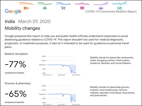
- At launch anyone will be able to go to the COVID-19 Community Mobility Reports website, pick their country and download a PDF that charts the % increase or decrease of movement across different high-level categories of places—such as retail and recreation, groceries and pharmacies, parks, transit stations, workplaces, and residential.
- The reports will show a percentage increase or decrease, rather than the absolute number of visits. And no personally identifiable information, like an individual’s location, contacts or movement, is made available at any point. The reports use aggregated, anonymized data to chart movement trends over time by geography.
- Google will release these reports globally, providing national trends for 130+ countries. At launch, some countries will also have state, province or regional-level insights which will be helpful because in many places that’s where public health decisions are made. At this time, only country-level information will be included in this report for India. The team is working to add that additional layer of insight to more countries.
How it could help: Google expects these reports could support decisions about how to manage the COVID-19 pandemic. Information about changes to essential trips can shape recommendations on business hours or inform delivery service offerings. That same kind of trend info on transportation hubs could tell authorities that they need to put on more buses or trains.
Privacy features
Google says it does not share data about any individual’s location, movement, or contacts. The insights it is sharing in these reports is the same as what we’re making available to public health authorities and governments.Insights are created with aggregated, anonymized sets of data from users who have turned on the Location History setting, which is off by default. People can turn off this setting at any time and delete their history. Google uses a technology called differential privacy, that adds artificial noise to the datasets so that no individual person cannot ever be identified.
Link to Google Blog for more details and all country reports