
Indian companies are giving the ancient art of cartography, a digital spin -- with 3-D, video and voice
Gurugram, National Capital Region: Robert Louis Stevenson, best known as the author of the kids' classic 'Treasure Island', once wrote: 'To travel hopefully, is better than to arrive.' It may have been true in an earlier age when anticipation was as enjoyable as achievement. Not anymore. Today, we want to get there by the fastest -- not, the most scenic -- route. The days of the well-thumbed school atlas have gone. Today's maps are digital, portable -- and vocal. And Indians are in the vanguard when in to comes to innovation in maps, location and navigation. A national conference on "Map the Future" in Delhi last week highlighted how desi enterprises are giving the ancient art of cartography, a digital spin -- with 3-D, video and voice.
The biggest domestic digital mapper is Okhla-based MapmyIndia whose maps created over a period of 22 years, fuel a wide slate of commercial solutions in navigation, location-based services and geographic information systems.
Yet, for you and me, the core of the company's Indian maps are available as a free app for Android or iOS (called simply 'Map') that we can run on a mobile phone. You can use it for step-by-step driving directions from your current location to most of the parts in India. And usefully, you can add your own home or business on the map in a 6-character code --eLoc- India's First Nation-wide Digital Address System, developed by Bangalore-based Reverie Language Technologies. Like the voice assistants that can be found on may phones, Map has a speaking mode. You can say 'HeyMap!' -- and ask for spoken directions. The app uses imagery from Bhuvan, ISRO's 2D and 3D imaging platform which will soon fuel NAVIC, the country's own sat-nav system that will make India, independent of GPS if required.
"Map" has variants that help Indian fisherman to remain within territorial waters. Idea Cellular uses essentially the same map base to create a GSM phone-based tracking solution for trucks and transport players. Reverie has also helped create India's first language-based keyboard for MapmyIndia maps: an Ola cab driver in Andhra Pradesh who may not know English, can use the Telugu version of the route finder.
Healthcare is another arena for map-based services -- and these same maps fuel "Visit" ( www.getvisitap.com) an Artificial Intelligence-driven m-health app from a Delhi start-up,for anyone to get free medical advice and also locate nearest pharmacy, hospital or ambulance service. Indeed harnessing digital maps can kickstart the most unusual services:
Aatapaha is a Gurugram-based lighting specialist who is working on a project to automate 1.5 million street lights in India. Location-sensitive smart street lamps can switch on and off depending on the traffic that flows past them.
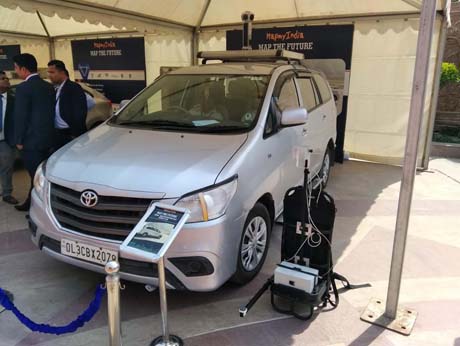
Perhaps the most exciting outreach of the maps business is the transition from 2D to 3D maps and from 3D static to video maps. Bangalore startup Vidteq ( acquired this month by MapmyIndia) has produced 3-D video maps for 20 cities that are used by builders, resorts and educational institutions. Their next project: the world's first Digital Map twin of the real world, with 3D and 360 degree views of indoors and outdoors, captured by GPS, laser and panoramic cameras, mounted on vehicle or as a backpack. At the Map the Future conference, these cameras were parked at the entrance to the venue appropriately called Kingdom of Dreams -- ready to record and digitize the world. This was one digital dream , that was being 'made in India' -- for the world.