
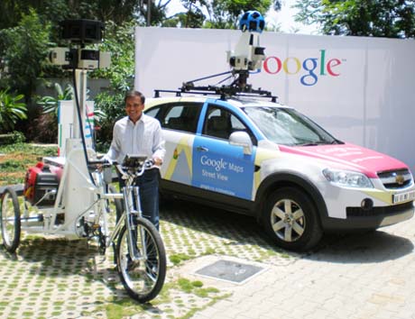
Google plans to bring Street View – the 360 degree street level imagery that complements Google Maps – to India. On Thursday, the company unveiled plans to begin gathering data for the streets of Bangalore, using a specially equipped SUV cars as well as tricycles ( to negotiate narrower lanes) . The vehicles are equipped with multiple 3D cameras with 15 lenses; laser distance measuring equipment and GPS trackers.
When the recording work is completed, Bangalore will become the first Indian city where users of Google maps can switch to 3-D imagery which gives an immersive experience of actually navigating streets, panning and zooming to change one’s view point, glide along streets and dive into side streets and lanes, much as one might do in a computer game – only this is the real thing.
Briefing the media in Bangalore, Google India’s Product Head, Vinay Goel, explained Street View had already been implemented in cities across 27 countries ( the nearest is Singapore), since the project was launched in 2007, greatly enhancing the user experience. In many cities, Street View had been used to highlight major tourist attractions, diving into historic buildings and museums. Street View is also available on the mobile phone versions of Google Maps.
Allaying security concerns, Goel stressed that the recording would be restricted to the public areas in cities, with the full knowledge of local authorities . cutting-edge face and license plate blurring technology was being harnessed to help ensure that passers-by and cars in the photographs can't be identified.
In all cities where Street View was available, users could drag and drop the PegMan icon to access the street view in any area of their choice. The application could also be accessed as an application which enterprises could harness to enhance their own Google Maps-based offerings.
How the street view is stitched together: Google combines signals from several sensors on the car, including a global positioning system (GPS) device, and monitors that measure speed and direction. The GPS device shows the car’s exact location most of the time, but sometimes factors like tall buildings in a city downtown block the signal, and data from the other sensors helps us fill in those gaps. They construct the car’s route accurately by combining these signals. Since they know exactly when along the line and in which direction each picture was taken, they can then match each image to a specific location, and even tilt and align the images with hilly terrain.
“When we photograph for Street View, we don’t want gaps in the imagery, so adjacent cameras on the car take overlapping pictures. To remove the overlap and create a continuous 360-degree image, we “stitch” the images together.We know the geometry of all of the different cameras in the system, and from that we determine where in the images we should “stitch” to create a unified panorama. We then apply special image processing algorithms to lessen “seams” where the images meet and create a smooth transition”..
For more details
http://maps.google.com/help/maps/streetview/learn/using-street-view.html
Do see our explanatory video for a few days in out Tech Video slot on the home page
May 27 2011